
Top 8 Wildflower Hikes In Colorado
The wildflowers are calling!
Summer is almost here! The temperatures are rising, the days are getting longer, and nature’s colorful show is taking center stage. Wildflower season has officially arrived in Colorado, turning meadows, hillsides, and mountain slopes into vibrant displays of color. From the stunning bluebells of the foothills to the vibrant paintbrush of the high country, there’s no better time to explore the outdoors and experience the beauty of Colorado’s wildflowers.
The best way to experience all of this?
Hit the trails with the freedom to explore at your own pace—and we’ve got the perfect spots for you to do just that. So, grab your camera, pack your hiking boots, and let’s dive into the top wildflower hikes in the Centennial State.
When is wildflower season?
Wildflower season in Colorado kicks off in June at lower elevations, with the peak of the bloom happening in July. Higher elevation hikes, especially in places like the Rocky Mountains and San Juan Range, are best for wildflower viewing from mid-June to late July. These plants thrive in the cool spring air and thrive in a variety of habitats, from foothill meadows to alpine tundra.
Depending on the elevation and weather, wildflowers continue to bloom through August, offering opportunities for breathtaking hikes well into the summer months. Whether you're looking for a leisurely walk or a more challenging summit, Colorado's diverse range of ecosystems offers something for every adventurer.

Wildflower Hikes & Festivals
While there are countless wildflower trails scattered across Colorado, we’ve curated a few of our absolute favorites to get you started on your wildflower adventure. These hikes represent just a glimpse of the breathtaking beauty that awaits you in the spring and summer months.
But if you truly want to immerse yourself in the heart of Colorado's wildflower season, don’t miss the Crested Butte Wildflower Festival, held every July. Known as the Wildflower Capital of Colorado, Crested Butte is the ultimate destination to celebrate nature’s beauty, with over 150 workshops, guided hikes, and unique activities dedicated to everything from photography to culinary arts.
After you’ve soaked in all that the festival has to offer, check out these featured hikes that will take you deeper into Colorado’s wildflower-filled wilderness.
1. Gold Hill Trail
White River National Forest
2.9-mile, out & back
1,070 ft. elevation gain
Easy
Family Friendly
Dogs on leash
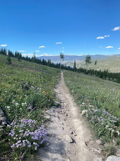
The Gold Hill Trail is a playground of wildflowers near Frisco and Breckenridge, CO. This easy jaunt will take you through a forest of evergreens and lodgepole pines. Though there are views of the Tenmile Range, it is the huge variety of wildflowers in the Upper Blue River Valley that will beguile the eye. There can be up to 50 types of wildflowers blooming along the trail. The clear cuts, designed to mitigate forest fires, are partially responsible for the array of colors and sizes of flowers best seen from June to August.
If you’d like to make the hike more challenging, there are lots of options to extend, including the Peaks and Colorado Trails.
Directions to trailhead from USDA Forest Service:
From I-70 take Exit 203, Frisco/Breckenridge, and travel south on HWY 9 through Frisco toward Breckenridge. After approximately 6.1 miles, turn right at CR 950. Immediately to your right is the trailhead parking area for the Gold Hill Trail. The trail begins across the road from the parking area.
2. Herman Gulch
Arapahoe National Forest
6.8-mile, out & back
1,781 ft. elevation gain
Moderate (more difficult near the end)
Dogs on/off-leash

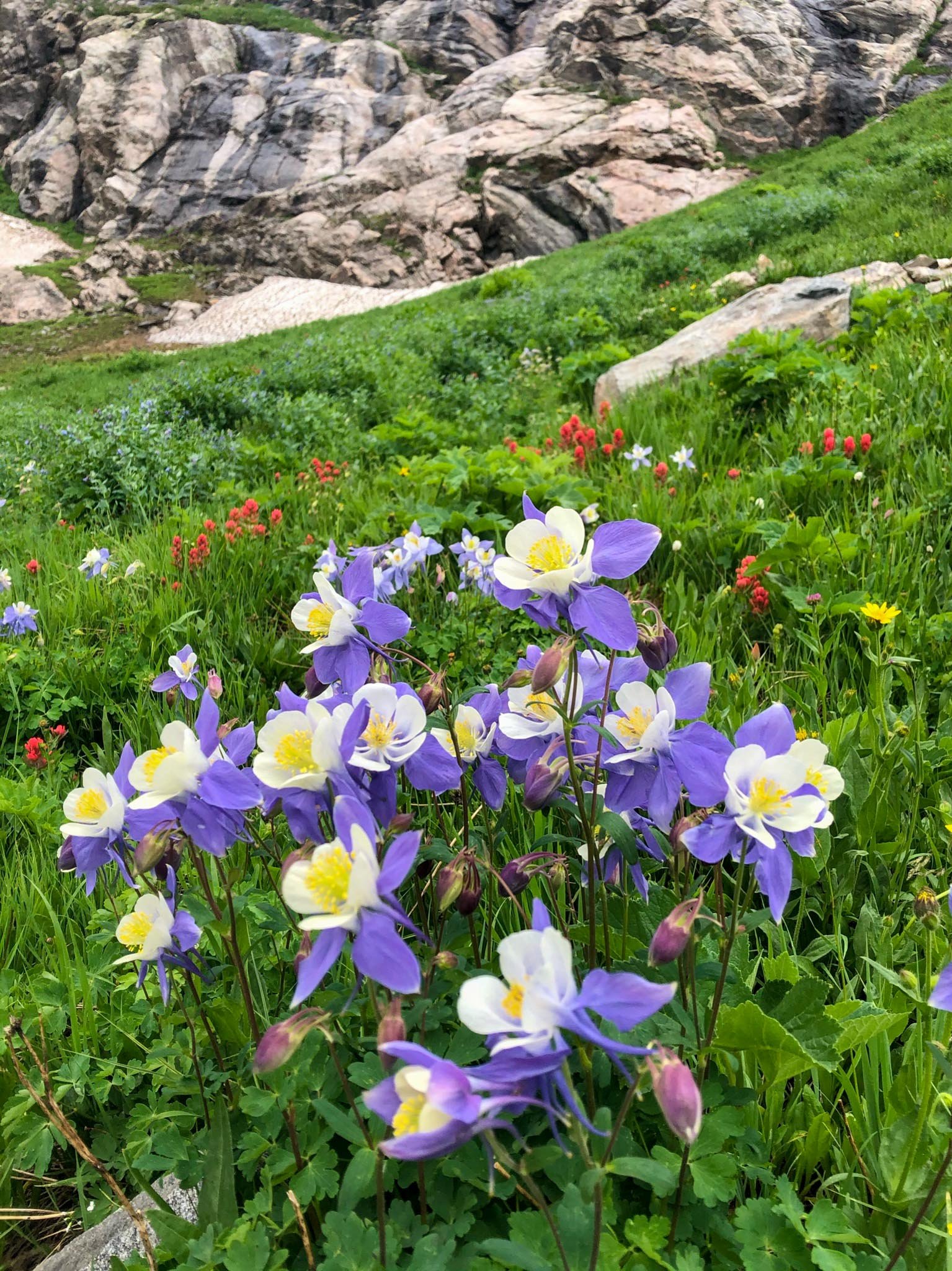
The Herman Gulch Trail, near Silver Plume and Idaho Springs, Colorado, has it all! Boasting 100 different species of wildflowers, a crystalline-green lake, and stately mountain vistas, your sweat and strain are well-rewarded. The trail is moderately strenuous but does get tough near the end. You’ll hike through forest, fragrant meadows, rocky ridges, and thousands of lovely flowers on your way to Herman Lake, which sits at almost 12,000 feet.
The popular trail is “a section of the Continental Divide National Scenic Trail” and is considered one of the best hikes in Colorado. It is peppered with blue columbine starting in mid to late June. However, the peak of blooming occurs in late July. Consider starting by 7 am to avoid crowds.
Directions to trailhead from USDA Forest Service:
From I-70 West take Exit 218, take a right toward Herman Gulch Road and a left onto Herman Gulch Road. Trailhead is a quarter mile west at end of the road.
3. Devil’s Thumb Lake
Indian Peaks Wilderness
12.1-mile, out & back
2,467 ft. elevation gain
Moderate, but long
Dogs on/off-leash

Don’t feel like you have to complete the entirety of this trail to reap the benefits! The trek to Devil’s Thumb Lake is long, but the views along the way are breathtaking. You’ll cross meadows of colorful wildflowers, see waterfalls, streams, and lakes, and listen to the flit of shimmering aspens. Look out for moose having a drink next to the columbine and bluebells! And don’t miss the stunning views of the Continental Divide.
Is it a challenging hike? Yes. But don’t fret. You can stop anywhere along the way for a break or a picnic. Catching your breath next to a blanket of wildflowers might just rejuvenate you. Blooming is best from mid-June to early July! Keep in mind: if it’s muddy, you might want to take the Devil’s Thumb Bypass, though the Devil’s Thumb Trail is more scenic.
Directions to trailhead:
From Boulder, take CO-119/Boulder Canyon Dr. west to Nederland. At the roundabout, drive south onto CO-119/South Bridge St. Turn right on Eldora Rd. which becomes Hessie Rd. ¾ of a mile past Eldora, the road will split with 4th of July Road going right and Hessie Rd. continuing to the left. Here is the parking lot for 2WD vehicles. If your vehicle is 4WD, you could continue up Hessie Rd. to a parking area closer to the official trailhead, but be aware that this road can flood during rains. There is also a shuttle from Nederland on weekends and holidays.
4. Willow Creek Trail
Roxborough State Park
1.4-mile, loop
164 ft. elevation gain
Easy
Family Friendly
No Dogs

Need to get away but you’re limited on time? Well, Roxborough State Park and the gorgeous Willow Creek Trail aren’t far away, yet the wildflower viewing will make your day. This easy, short loop becomes a heavenly escape with the arrival of spring and summer. Not far from Littleton, Colorado, you’ll be surrounded by larkspur, paintbrush, Canada violets, and poison ivy. Yes! We said poison ivy. Watch out for it!
Bring the family (except for the dog) for a quick getaway and bring your camera to capture the beautiful blooms! Be aware that there is a $10 entrance fee for vehicles, $4 per person on foot.
Directions to trailhead from Colorado Parks & Wildlife:
From US-85 S/Santa Fe S, Turn right (west) on Titan Road 4.2 miles south of the C-470 intersection. Continue heading west on Titan Road. It will become North Rampart Range Road. At the intersection of North Rampart Range Road and Roxborough Park Road, turn left onto Roxborough Park Road. Take the next right on East Roxborough Drive to enter the park.
From CO-121 S/S. Wadsworth, turn left on Waterton Road. Turn right (south) on North Rampart Range Road. At the intersection of North Rampart Range Road and Roxborough Park Road, turn left onto Roxborough Park Road. Take the next right on East Roxborough Drive to enter the park.
5. Ice Lake & Island Lake Trail
San Juan National Forest
7.2-mile, loop
2,670 ft. elevation gain
Difficult
Dogs on leash

Ice Lake

Island Lake
Also considered one of the best hikes in Colorado, the Ice & Island Lakes Trail, near Silverton, is well worth it on an average day but even more awesome during the blooming season! This hike is a challenge, for sure, but it is also one of the most beautiful trails. Set against the backdrop of rocky peaks and blue-green water, you’ll find basins filled with wildflowers.
Late July is the best time to embark on your journey past waterfalls on the way to the unreal blue waters of Ice Lake and then Island Lake. Every turn presents vistas as pretty as a picture from a magazine (be sure to take plenty of your own)! Do not let the mileage and experience level divert you from this amazing hike, but try to get there early and avoid the afternoon thunderstorms.
Directions to trailhead from USDA Forest Service:
From Silverton, CO, follow US-550 north of Silverton about 2 miles and turn onto FDR #585 (South Mineral Creek). The trailhead is at the entrance of South Mineral Campground. There is limited parking.
6. Gem Lake Trail
Rocky Mountain National Park
3.3-mile, out & back
990 ft. elevation gain
Moderate
No Dogs
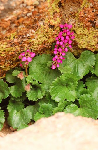
Gem Lake, outside Estes Park, Colorado, is a fortuitous phenomenon. The lake isn’t fed by any “true inlet or outlet stream - surrounding rock traps, collects, and steers water into the small basin,” informs ProTrails. And it’s home to a vibrant, pink wildflower species, Telesonix jamesii, that grows out of the cracks in the granite formations that surround the lake.
Now, this hike is short, but it practically goes straight up to its destination. However, the views of Estes Park, the Continental Divide, and Longs Peak will distract you as you huff and puff your way up. And it’s all downhill on the way back! Take in the unique rock formations and flittering aspens and breath in the fragrant wildflowers and piny ponderosas on this wonderful little hike. Best blooming is from late April to early May.
Directions to trailhead from ProTrails:
From downtown Estes Park, go north on MacGregor Ave, which becomes Devil’s Gulch Road shortly after crossing US Highway 34. Continue on Devil’s Gulch Road past MacGregor Ranch. The turn-off for the trailhead is less than a mile ahead and marked by an NPS sign. Turn left (north) on the trailhead access road, which dead-ends in several hundred yards.
7. Well Gulch
Charles A. Lory State Park
1.8-mile, loop
603 ft. elevation gain
Easy
Family Friendly
Dogs on leash

Another lovely little afternoon hike is the Well Gulch trail near Bellevue and Fort Collins, Colorado. This is an easy nature walk rich in Douglas fir, ponderosa, and wildflowers of every shape, size, and color. Listen to the soothing sounds of the waterfall and creek and tune out the bustle of life while inhaling the floral aroma. Bring the whole family (dog included!) to appreciate the lovely flora, and learn a little something as you stop by the numbered information stations.
The best blooming is from late May to June. If you’d like more of a challenge, you can extend this hike by taking the Timber Trail. Remember that Lory State Park will charge an entrance fee per vehicle or per person on foot.
Information about trailhead from All Trails:
From Fort Collins, take US Hwy 287 north through Laporte (stay on the route that goes through Laporte, not the 287 bypass). At Vern's Place, veer left onto County Rd. 52E. Then, make a left on County Rd. 23E in Bellvue. Go south 1.4 miles to County Rd. 25G. Turn right, and continue 1.6 miles to Lory Park Rd. Turn left onto Lory Park Rd., and stop at the entrance station to pay the $6 entrance fee. From the entrance station, continue south on Lory Park Rd. about 1 mile to the Well Gulch Trailhead (look for the trailhead sign on the right, the parking lot is on the left side of the road).
8. Rustler Gulch
Maroon Bells, Snowmass Wilderness
9-mile, out & back
1,791 ft. elevation gain
Moderate
Dogs on leash
Yes, it’s a long trail, but every step is rife with brilliant wildflowers! If you travel to the “Wildflower Capital of Colorado,” what else would you expect? The trail is not difficult, and between the mountain views and the rampant flora, it is well worth the time you’ll spend on it. Bring your camera because you’ll see around 114 species of wildflowers blanketing the land. Best blooming is from late June to August!
Directions to trailhead from Hiking & Walking:
From Crested Butte, head north on 6th Street, which turns into Gothic Road/CO 317 for 10.5 miles. Turn right (east) at the Rustler Gulch trailhead. Follow the access road for 0.1 miles to the East River. If driving a passenger car or if the water is high, park along the Gothic Road or travel 500-ft. up the access road to a small parking lot on the left (north) side of the road. Otherwise, cross the river and follow the moderately-steep access road for a mile. Right before the trailhead, there are pull-offs along the side of the road with space for 5-6 vehicles. Warning: Use extreme caution when crossing the river. The water can be very deep. A sign warns of cars totaled trying to cross the river. When in doubt park on the east side of the river and walk.

Honorable Mentions
Everyone has their favorites. Here are a few that didn’t make our shortlist, but are still worth a walk:
Little French Gulch Trail
Yankee Boy Basin
Palmer Trail Loop
Aspen to Crested Butte
Fourth of July via Arapaho Pass
Alpine Loop Scenic Byway
Lone Eagle Peak
Butler Gulch
Mayflower Gulch
Big Horn Creek

How to Get There!
So you’ve picked your wildflower adventure, perhaps you’ve even decided to stay a few days. Or maybe you’ll road trip and do them all! Now, how are you going to get there?
Titus Adventure Company is the one-stop shop for your next Colorado adventure. Our Denver camping rentals include campervans, 4WD trucks, SUVs, and Jeeps with rooftop tents and campers. But we also make sure that your trip is exhilarating, taking care of the details so that you can enjoy yourself! Contact us today for trip advice, adventure rentals for your Colorado trip, or to check on the availability of our 4WD rental vehicles.
And we have even more Colorado camping rentals available. Do you need a stove? A fishing set-up? A warm sleeping package? We’ve got it all ready to go, contact us or check availability today and start planning your next expedition!
For more adventure blogs, take a look at What is Dispersed Car Camping and How to Do It, Early Season Camping in Colorado, or Spring Mountain Biking in Colorado and Utah!