
Colorado's Scenic Drives—2WD & 4WD! Part Two: 4WD
Scenic Drives—2WD & 4WD!
In Part Two of our Colorado Scenic Drives blog, we’re getting deep into the backcountry with some amazing 4WD roads and trails. The harder to get to, the more to see, in our opinion!
Definitely take a look at our 2WD Scenic Drives, too. These are great whether you are a seasoned driver or not!
Which brings us to an important disclaimer: If you are unsure about driving your 4WD vehicle up a trail—don’t do it. There is no reason to risk lives or end up stuck, costing you and the forest service thousands of dollars to dig you out. See below for how to be prepared to do these drives. But if you are feeling up for it and appropriately equipped, get out there and explore!
Without further ado! Here is a list of our favorite scenic, 4WD drives. Take your hiking boots, take a picnic, or take a tent and spend the weekend in the glorious outdoors! And if you need a Colorado adventure rental to help you on your trip, you know who to call!
4WD Scenic Drives Around Colorado

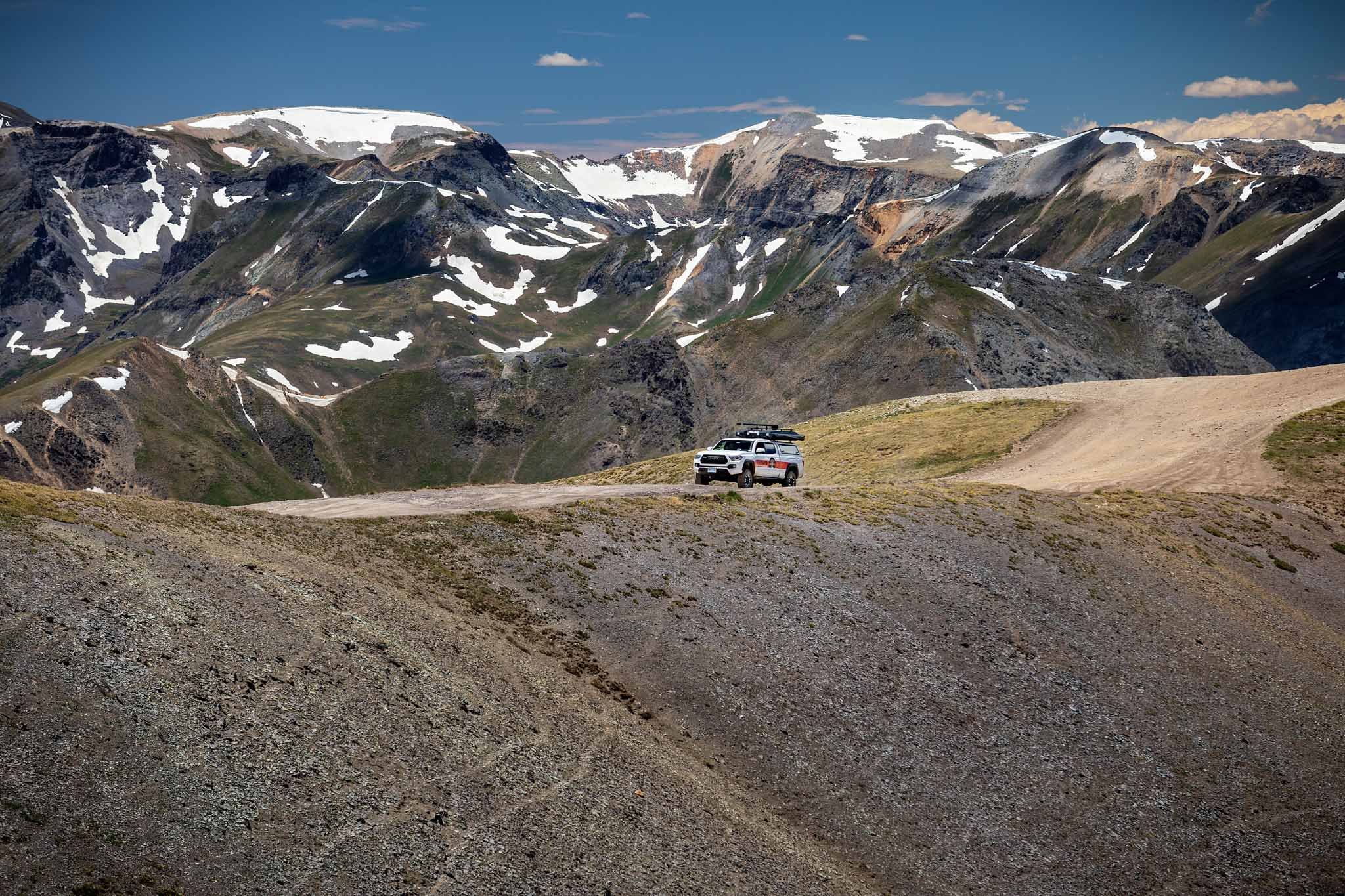
Alpine Loop
63-miles
Silverton to Lake City
12,000-ft. summit
Best in June to September; closed in winter and often muddy
Trail rating: Black
This drive has a narrow window when it isn’t covered in snow or mud, but it is well worth the wait! You’ll travel through the historic towns of Silverton, Lake City, and Ouray (and the ghost towns of Animas Forks and Capitol City!) with enough food, drink, shopping, history, and recreation to keep you busy for days. But then, you’ll traverse two high mountain passes in the San Juan National Forest, where views, wildflowers, and wildlife abound. Camp and hike along the way, fish and boat at the second largest natural lake in Colorado, Lake San Cristobal.
Remember: 4WD and high-clearance needed for certain passes. Check the road conditions and fill up your gas when you can. Allow at least 7 hours for the trip.
A final note: The section of road from Engineer Pass down into Ouray (sometimes called Mineral Creek) is a nasty, rocky 4x4 road. It is best to be avoided.
Alpine Loop.
Old Fall River Rd
11-miles one-way only going east to west (uphill)
Horseshoe Park (RMNP) to Fall River Pass/Alpine Visitor’s Center
11,796-ft. summit
Best early/mid-July to early October; closed in winter/spring
Trail rating: Green
Driving Old Fall River Rd is a yearly ritual. This “nature drive,” opened in 1920, starts in a green, forested valley and rises past waterfalls and meadows, through varying rock formations, and climbs above the tree line to a desolate, yet breathtaking, alpine tundra. It is a transformative drive from which you might spot elk, mule deer, or marmots. Stop at Chasm Falls, hike the Chapin Creek Trail, or grab a snack and chat with a ranger at the Alpine Visitor Center before you head back down on the paved Trail Ridge Road.
The drive up doesn’t require a 4WD vehicle, but it doesn’t hurt. It is a one-way, dirt and gravel road with lots of narrow switchbacks, no guardrails, and a 15 mph speed limit.

Weston Pass.
Weston Pass
27-miles
Fairplay area to Leadville area
11,921-ft. summit
Best mid-June through September; closed in winter
Trail rating: Green to Blue
This route, connecting Fairplay and Leadville, has been used for hundreds of years. “The Road To Riches” is another wonderful place to see the aspens change color in the fall, with lots of dispersed camping and opportunities to hike and fish in the Buffalo Peaks Wilderness. Not to mention the awesome Weston Pass backcountry hut for those looking for a beautiful summer getaway or some backcountry skiing adventures in the colder months. The road winds between pine forests and alpine terrain with gorgeous views.
Though parts of this drive will be easy, others will be challenging and need 4WD and high clearance.
Buffalo Pass.
Buffalo Pass
32-miles
Steamboat Springs to near Walden
10,339-ft. summit
Best July to November; closed December 1 to June 30
Trail rating: Blue
This drive, through Routt National Forest, is a recreational wonderland. Hiking, biking, camping, fishing, and kayaking/paddleboarding options can be found among the alpine lakes, meadows, and forests. Start off in Steamboat Springs or the “Moose Viewing Capital of Colorado,” Walden, and take anywhere from a few hours to several days to enjoy. If you’re looking to leaf-peep, the fall colors are brilliant! Take in the aspen and pine forests and the many crystalline lakes while you camp at one of two campgrounds (Dry Lake or Summit Lake) or in a dispersed space. In the winter, the road is closed to cars, but you can still recreate on a snowmobile or pair of skis!
2WD may suffice on the east side, but around the top of this pass and west side, 4WD, high clearance vehicles are necessary.
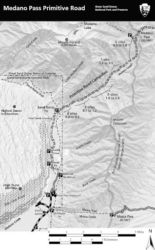
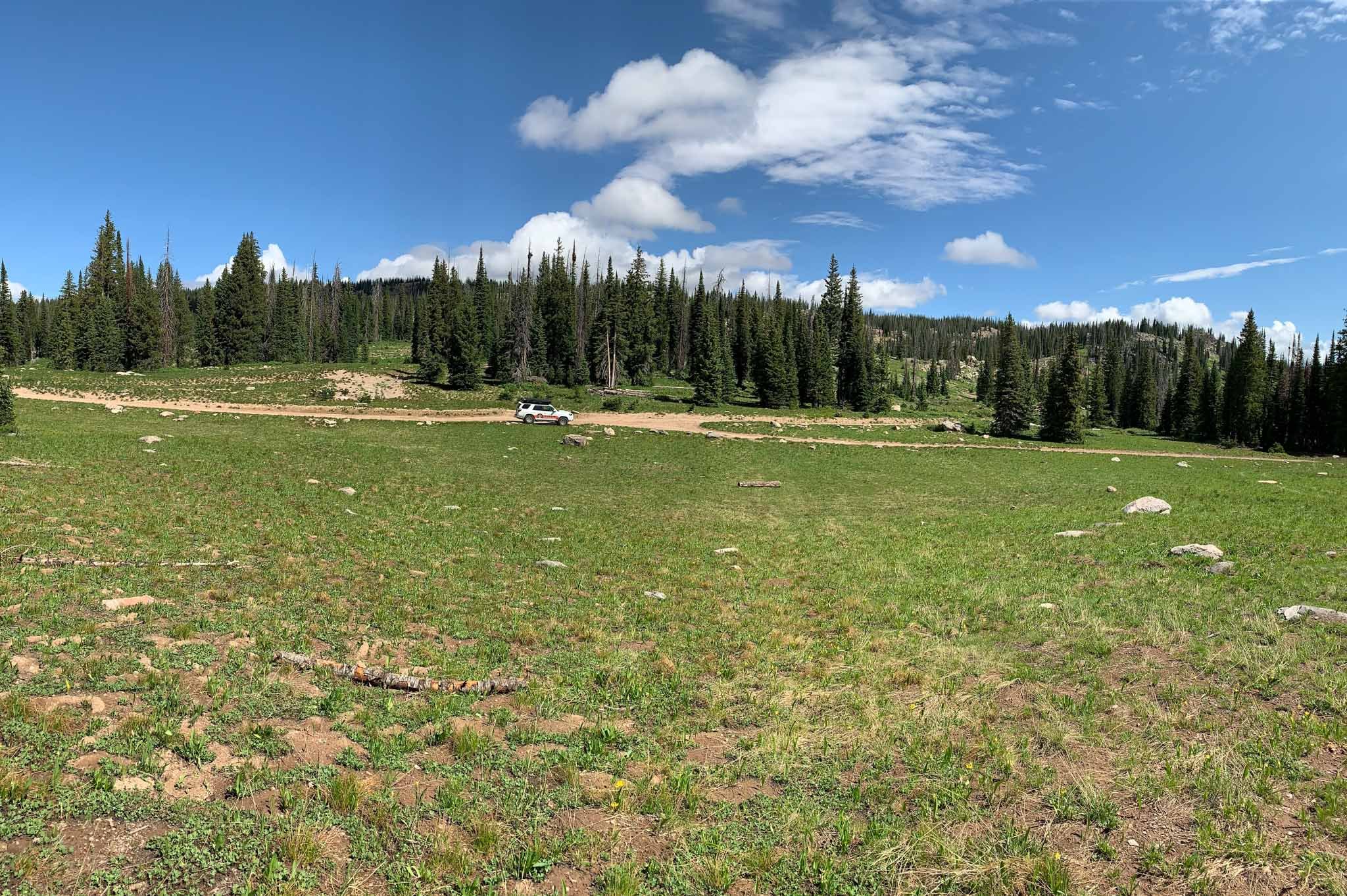
Medano Pass Primitive Road
22-miles
Great Sand Dunes to Wet Mountain Valley
10,040-ft. summit
Best in warmer months (spring, summer, fall)
Trail rating: Blue to Black
The Medano Pass Primitive Road isn’t for the faint of heart. This is a real 4WD adventure! You’ll be crossing Medano Creek nine times and traversing deep sand and rough rocks. Storms come on quick here, so make sure you are equipped for an overnight stay. Use this useful mileage chart that describes points of interest and the 21 roadside, first-come, first-served campsites. Be on the lookout for bighorn sheep and enjoy the views of dunes, meadows, cliffs, and an old homestead.
Save at least 2.5 to 3 hours for your trip. This is definitely a trip you’ll want to be prepared for. Check the road conditions before you leave, and also learn about reducing your tire pressure on days that the sand is “dry and soft.” You may need to bring your own air compressor. 4WD is an absolute must.

Medano Pass.

Marshall Pass.
Marshall Pass (near Monarch Pass)
30-miles
Sargents to Mears Junction
10,842-ft. summit
Best in June through October; closed in winter and spring
Trail rating: Green
This backcountry route between Salida and Gunnison was discovered in 1873. The road was completed in 1880, and the current path follows the original railroad route (shut down in 1955), traversing the continental divide between Denver and Salt Lake City. Great for leaf-peeping and wildlife-viewing with plenty of aspens and big horn sheep. Hike or bike on the Colorado Trail or Marshall Pass Trail and snowmobile or snowshoe in the winter. There’s plenty of dispersed camping in Gunnison National Forest so you can make a trip of it or just enjoy a 4 hour or less day trip with piny forests and majestic vistas.
The road ascends slowly, in line with the original railway. You could drive this in a 2WD in good conditions.

Cumberland Pass
16-miles
Pitkin to Tin Cup
12,034-ft. summit
Best in summer and fall; closed November to May
Trail rating: Green to Blue
For history buffs, view seekers, and adventure drivers alike, this road, connecting the quaint mining towns of Pitkin and Tin Cup, is a breath-taking day trip. Built in 1882 to transport ore from the many mines sprinkled amidst the pines, now it showcases stunning views of the Sawatch Mountain range. It’s considered the highest standard passenger vehicle road in the U.S. Make a day of it with a picnic or a hike, or a visit to town.
Though most of this drive is easily traversed (just tight turns and a narrow path) you’ll probably want to have a high-clearance auto on the Tin Cup side.
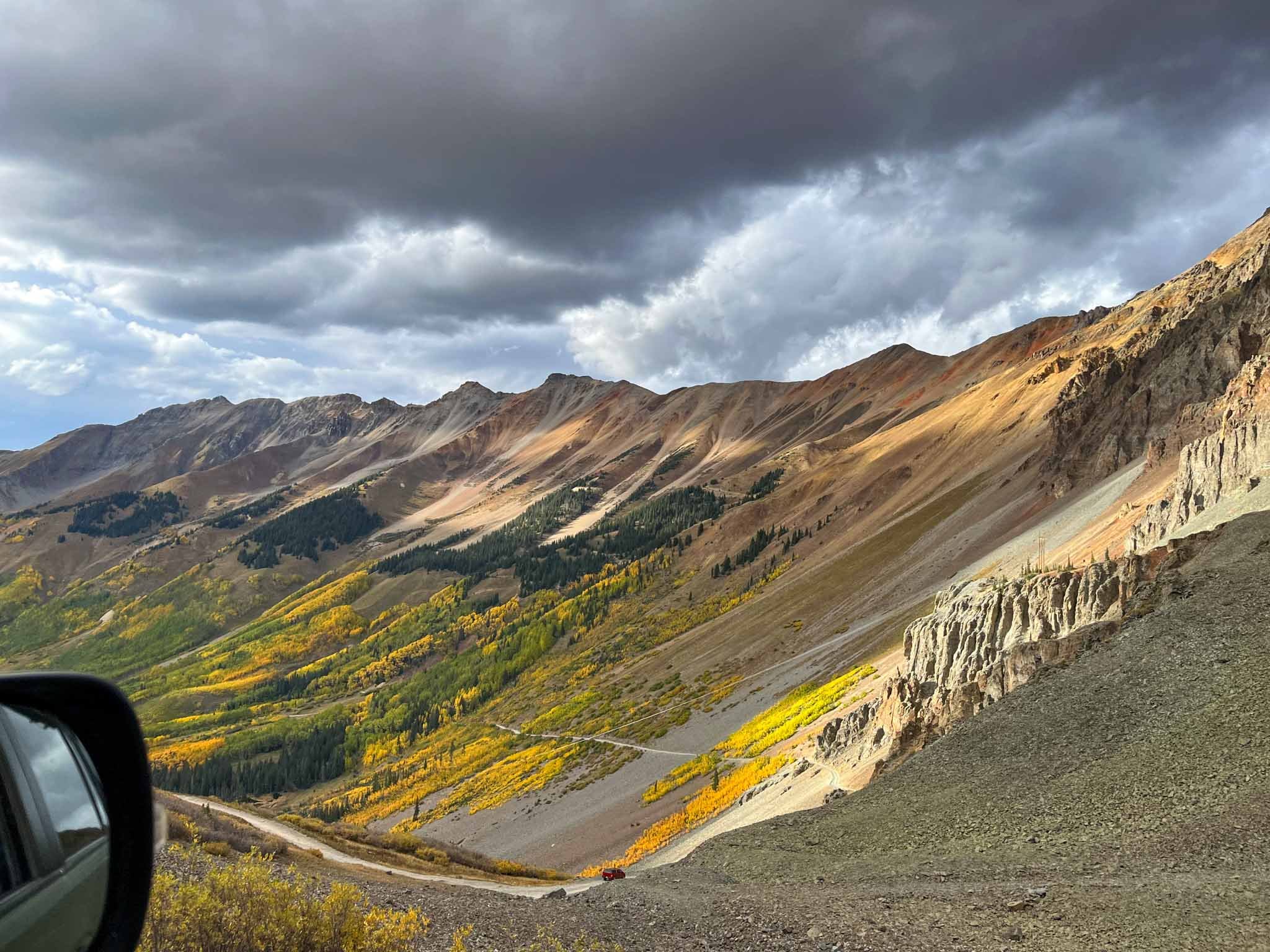
Ophir Pass.
Ophir Pass
26-miles
Telluride to Silverton
-Or-
8-miles
Highway 145 to Highway 550
11,789-ft. summit
Best in the summer between mid-June and September; not maintained/closed in snow
Trail rating: Black
Driving Ophir Pass is an absolutely stunning adventure through the mountains of San Juan National Forest and history. What now is the lovely little town of Ophir was established in 1878 as a gold mining town, and you can still see the remnants. The pass, winding between three fourteeners (Mount Wilson, Wilson Peak, El Diente), South Lookout Peak, and Lizard Head, was first used by the Navajo on hunting trips. We cannot get over the crazy views on this drive! You’ll be in awe of the peaks, rivers, and wildflowers along this gorgeous pass. But keep your eye on the road! If you’re an avid mountainbiker, try the Columbine Lake Trail.
Though mostly smooth, there are a couple of iffy spots where confidence and 4WD, high-clearance vehicles are needed. And wild weather can sweep through quickly. You might see 20-ft. high snow banks near the summit!
How to be prepared for a 4x4 vehicle trip
Packing List
Plenty of food and water
Good shoes
Warm clothing layers
Cell phone
GPS communication device (like Bivy Stick or Garmin inReach)
Maps
Headlamp
Lighter
Your vehicle
Good off-road tires. These are different from just “all-season” tires most vehicles come with.
Know how to use 4Hi and 4Lo
Good brakes
Recovery Gear to Consider
Shovel
Deflator tool to lower air pressure in tires while on 4x4 trails
Air compressor to re-inflate tires to highway pressure
Kinetic tow rope and soft shackles
Tool kit
Warm Up With 2WD!
If you need a little warm-up before you head out on these baddies, start off with our favorite easy (yet utterly breathtaking) 2WD scenic drives. Or just do them all because Colorado is a beautiful state to hike, bike, and drive through! Now quit reading! Get out there and adventure already!
Reminder: Always drive safely and within your comfort zone. Right-of-way is always given to those going uphill.
Get Your Adventure Rentals Here!
You know that Titus Adventure Company is the one-stop shop for adventure, right? If you need help getting to any of these scenic drives we’ve got the 4WD camping adventure rental for you, right here in Denver, Colorado!
Our Denver camping rentals include campervans, 4WD trucks, SUVs, and Jeeps with rooftop tents allowing you to camp in serious comfort and style. Not to mention, vehicle rentals come with all the gear for a camping trip (and our expert suggestions, like when to camp in Colorado and to always book your campsites ahead of time), taking care of the details so that you can enjoy yourself!
Contact us today to schedule an adventure rental for your Colorado road trip, or to check on the availability of our 4WD rental vehicles.
For more from Titus Adventure Company on camping and recreation, check out our blog!